Geofencing is one of those technologies that sounds simple but delivers a surprising amount of value when applied to logistics. Imagine a virtual fence around a warehouse, a loading dock, or a customer site, and every time a truck, pallet, or worker crosses that boundary you get an actionable alert. For Deflog readers who follow innovations and technology in logistics, geofencing is a practical, scalable tool that can boost productivity, safety, and compliance across the supply chain. In this article we will explore what geofencing is, how it works in a logistics context, concrete use cases, and a practical guide to implementing it successfully. By the end you will know not only why geofencing matters but also how to start small and scale with confidence.
What geofencing is and why it matters for logistics
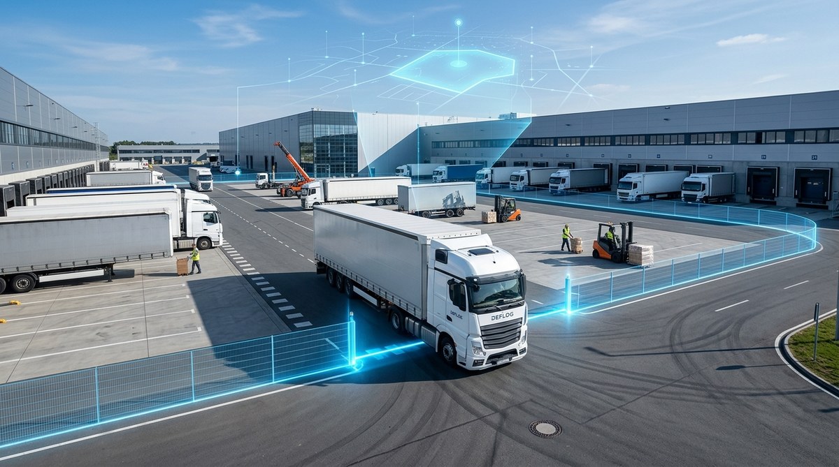
Geofencing creates a virtual perimeter around a real world location. This boundary can be as simple as a circular radius around a warehouse or as complex as a polygon that follows the shape of a loading yard, a.k.a. a geofence. When an asset, vehicle, or person equipped with a GPS device, a beacon, or a compatible smartphone crosses that boundary, a trigger event is generated. That event can arrive as a real time alert, a data point for a dashboard, or an automated workflow in your transport management system.
The logistics value of geofencing comes from three core capabilities:
- Real time visibility: you instantly know where assets are, when they enter or exit a zone, and how long they linger there.
- Process automation: boundary events can trigger jobs, notifications, or policy enforcement without human intervention.
- Compliance and safety: geofences help ensure rules are followed in sensitive areas and that critical workflows happen within approved timing windows.
Geofencing is especially powerful when combined with the core tech stack that Deflog readers care about, including event driven architectures, IoT sensors, and integrated ERP systems. It also aligns with broader topics you may already be exploring, such as GDPR compliance for location data, the rise of electric trucks with defined charging hubs, or voice controlled workflows that rely on precise location signals.
How geofencing works
- Define the boundary: Specify the geographic shape and size of the fence. This can be a circle, a polygon, or a set of nested zones with different rules.
- Attach a location capable device: Vehicles, assets, or personnel carry a device or app that can report position. This can be an OBD device, a rugged smartphone, a BLE beacon, or an asset tag.
- Monitor and compare: The system continuously compares the device location with the boundary. If the asset crosses the boundary or dwells inside a zone, an event is generated.
- Trigger actions: Predefined rules determine what happens next. It could be an alert to a dispatcher, an update to a WMS or TMS, or an automatic job in an orchestration layer.
- Analyze and act: Data is stored for analytics, enabling better planning, route optimization, and continuous improvement.
Geofence types that matter in logistics
- Asset geofences: around depots, yards, or gates to track when a vehicle or container enters or leaves.
- Yard and terminal geofences: shape the exact areas within a facility to optimize dock scheduling and pallet movements.
- Customer site geofences: notify when a delivery is within a defined radius for precise ETAs and proof of delivery workflows.
- Safety zones: restrict access to hazardous areas or enforce speed limits in certain sections of a site.
- Charging and service geofences for electric fleets: automatically route drivers to charging hubs and monitor dwell times.
- Work crew geofences: ensure field staff are entering and leaving job sites correctly, useful for time tracking and safety.
Use cases to boost efficiency
Geofencing touches many parts of the logistics ecosystem. Here are concrete use cases that teams commonly roll out to improve performance.
Fleet management and routing
- Real time vehicle tracking and ETA updates to customers and planners.
- Compliance enforcement for route rules and lane restrictions.
- Automated alerts when vehicles deviate from approved routes.
- Insight into dwell times at gates, warehouses, and customer sites to optimize scheduling.
- Integration with routing engines to adapt plans on the fly as conditions change.
Warehouse and yard management
- Gate control and dock door scheduling based on vehicle proximity.
- Yard movement visibility to prevent stray moves and misplacements.
- Inventory traceability by linking geofence events to container IDs and pallet locations.
- Optimized staging areas by automatically relocating assets as soon as they cross a boundary.
- Improved security by detecting unauthorized movement after hours.
Last mile delivery and curbside operations
- Pre arrival notifications and proof of delivery workflows triggered by entering customer geofences.
- Dynamic ETA updates based on actual arrival within a defined radius.
- Automated delivery windows synchronized with customer preferences and driver availability.
- Exceptions management when deliveries cannot occur within the planned window.
Compliance and safety
- Enforcing restricted zones to avoid entering hazardous areas or times when access is limited.
- Speed and idling monitoring in critical areas, with alerts when rules are breached.
- Training and audits supported by data trails showing who entered which zone and when.
Security and loss prevention
- Early warning of unauthorized vehicle movement within highly secure premises.
- Verification that high value assets pass through approved checkpoints.
- Tamper detection when a tagged asset leaves a safe zone without proper authorization.
GDPR and data privacy considerations
Location data is powerful but sensitive. When implementing geofencing for logistics, it is essential to design with privacy in mind from the start.
- Data minimization: collect only what you need to achieve the objective. If you only need entry exit events, avoid storing precise continuous location data.
- Purpose limitation: clearly define and communicate the purpose of collecting location data to drivers, operators, and customers.
- Access controls: ensure that only authorized personnel can view geofence data and system logs.
- Retention and deletion: establish retention periods and automatic deletion rules for location data that is no longer needed.
- Data security: encrypt data in transit and at rest; use secure APIs and regular security audits.
- Transparency and consent: provide clear notices and obtain consent where required by law and company policy.
- Data subject rights: ensure processes exist to handle access or deletion requests if applicable.
By weaving privacy into the geofencing program, you protect the organization, respect worker rights, and maintain trust with customers and regulators. This approach also supports responsible data governance that aligns with GDPR and similar frameworks in other regions.
Implementation guide: how to deploy geofencing in logistics
A well planned rollout reduces risk and accelerates value. Here is a practical, step by step guide.
- Define objectives and success metrics
- What problem are you solving? e.g. reduce dock wait times, improve on time delivery, or enhance yard security.
- How will you measure success? Examples include ETA accuracy, dwell time reductions, or incident counts.
- Map your geofence footprint
- List all places that will benefit from geofencing: depots, yards, gates, customer sites, charging hubs.
- Create boundary shapes that reflect real world spaces while remaining technically practical for devices.
- Choose the right devices and sensors
- Vehicles with GPS trackers or OBD devices.
- Assets with BLE beacons or RFID tags for precise indoor positioning.
- Driver apps on smartphones for flexible coverage.
- Design the software architecture
- Integrate geofence events with your existing stack: WMS, TMS, ERP, and dashboards.
- Leverage an event driven architecture to react to boundary events in real time.
- Establish API connections for data sharing with external partners or customers.
- Define rules and alerts
- Entry and exit events, dwell time thresholds, and speed limits inside zones.
- Notification routing to the right people or systems (dispatchers, site managers, or automated workflows).
- Pilot the program
- Start small with a single depot or a controlled route.
- Collect feedback from drivers and planners, adjust geofence shapes and thresholds.
- Scale and optimize
- Expand to additional sites and use cases based on pilot results.
- Continuously review KPIs, update boundaries to reflect changes in facilities or processes.
- Train and engage employees
- Provide clear instructions on how the geofencing system works and what is expected from drivers and operators.
- Offer ongoing support and quick reference guides.
- Ensure governance and compliance
- Document data handling practices and ensure alignment with privacy laws.
- Regularly audit geofence configurations for accuracy and relevance.
- Monitor, learn, and iterate
- Set up dashboards showing geofence events, incident trends, and operational KPIs.
- Use insights to adjust routes, schedules, and yard layouts for even better results.
Choosing the right tech stack for geofencing
A successful geofencing program depends on picking the right mix of hardware, software, and data handling capabilities.
- Hardware and devices
- GPS trackers and OBD devices in vehicles for external location signals.
- BLE beacons and RFID for indoor and yard positioning.
- Smartphones and tablets for flexible workforce engagement.
- Software and platforms
- A geofencing engine capable of handling multiple boundary types and complex rules.
- Strong integration with WMS, TMS, ERP, and data visualization tools.
- Event driven architecture to process boundary events in real time.
- Data and privacy controls
- Data processing agreements with vendors.
- Access control, encryption, and secure APIs.
- Clear data retention policies and anonymization options when appropriate.
- Security and reliability
- Redundant connections and offline capabilities where possible.
- Regular security updates and patch management.
- Audit trails and reporting to support compliance and governance.
Benefits and potential challenges
Investing in geofencing can deliver measurable benefits, but like any technology project it comes with potential hurdles.
- Benefits
- Improved on time delivery and dock efficiency.
- Reduced premature gate entries and better yard management.
- Enhanced security and loss prevention.
- Stronger customer service through precise ETAs and proofs of delivery.
- Better compliance with internal rules and external regulations.
- Common challenges
- Accuracy limitations in dense urban areas or under heavy tree canopies.
- Battery life and device management for mobile assets.
- Complexity of configuring multiple geofences across many sites.
- Privacy concerns and the need to obtain appropriate consent or approvals.
- Change management and ensuring user adoption across drivers and operators.
By anticipating these challenges and applying best practices, you can keep the program focused on real value rather than complexity.
Best practices for successful geofencing programs
- Start with high value, low complexity use cases to demonstrate ROI quickly.
- Keep geofences aligned with actual site layouts and operational workflows.
- Use incremental thresholds and layered fences for more nuanced control.
- Validate data quality frequently and fix any measurement inconsistencies early.
- Establish clear escalation paths for boundary breaches and exceptions.
- Document the privacy expectations and make training part of the rollout.
- Continuously collaborate with operations teams to refine geofence rules based on changing conditions.
- Integrate geofence data into dashboards that are meaningful to dispatchers and site managers.
The future of geofencing in logistics
Geofencing is not standing still. The next wave mixes more sensors, smarter rules, and deeper integration with other technologies you already rely on.
- AI driven optimization of geofence shapes and thresholds based on historical performance and predictive analytics.
- Multi sensor fusion that combines GPS, indoor positioning, camera data, and environmental sensors for higher accuracy.
- Dynamic geofences that adjust in real time to events like traffic, weather, or urgent delivery windows.
- Deeper integration with electric fleets, enabling automatic routing to charging hubs as part of boundary logic.
- Enhanced privacy by design, with configurable data minimization and user consent flows baked into every deployment.
In addition, geofencing connects well with other Deflog topics you may be exploring, such as event driven architecture, GDPR compliance, smart charging for electric trucks, and advanced training methods like VR for operational readiness. The synergy between these innovations helps logistics organizations become more agile, resilient, and data driven.
Takeaways for Deflog readers
- Geofencing offers a practical, scalable way to improve visibility, safety, and efficiency across the supply chain.
- A thoughtful implementation plan reduces risk and accelerates value realization.
- Privacy and data governance must be a core part of any geofencing initiative.
- The most successful programs start with clear objectives, strong integration, and ongoing stakeholder engagement.
- The technology is maturing and will increasingly rely on AI, multi sensor data, and tighter integration with other modern logistics technologies.
Aan de slag: turning insights into action
If you are ready to pilot geofencing in your logistics environment, here is a compact action plan you can adapt to your organization.
- Action 1: Pick one site to pilot
- Define the boundary and the primary objective (for example gate throughput or delivery punctuality).
- Action 2: Select devices and data partners
- Choose a mix of GPS trackers, BLE beacons, and driver apps that can feed your geofence engine.
- Action 3: Design the rules
- Create entry exit alerts, dwell thresholds, and safety geofences that reflect your real world processes.
- Action 4: Build integration
- Connect the geofence engine with your WMS and TMS; set up dashboards for real time monitoring.
- Action 5: Run a short pilot
- Track performance, collect feedback, and adjust the boundaries as needed.
- Action 6: Scale with governance
- Document privacy practices, define retention periods, and roll out to additional sites.
As you move from pilot to scale, maintain a tight feedback loop with operations teams. Roadmaps should accommodate evolving site layouts, new customer requirements, and changes in fleet composition including electric trucks and alternative fuels.
Conclusion
Geofencing is a powerful, practical tool for modern logistics. It blends real time visibility with automated workflows and robust governance to unlock improvements across fleet operations, warehouse yard management, and last mile delivery. For Deflog readers, geofencing aligns nicely with ongoing conversations about voice controlled systems, GDPR compliance, electric trucks, event driven architectures, VR training, and even quantum computing for supply chains. It is a technology that invites experimentation, but with a clear plan, measurable goals, and a strong privacy posture, it can become a durable competitive differentiator.
If you want to learn more about how geofencing can be tailored to your specific logistics context, Deflog is here to help. Our Dutch portal focusing on innovations and technology in logistics provides insights, case studies, and practical guides that translate complex tech into actionable steps. Whether you operate a single distribution center or a global network, the geofencing playbook described in this article can be adapted to your needs and integrated with your existing digital backbone.